-
Ed Parsons gets heavy, Fake SteveC gets heavier
Some interesting and amusing posts have shown up over the weekend that I just couldn’t go without mentioning. Ed Parsons posted an article about Nestoria’s new property site based around OSM maps. In this article Ed brings up the obvious problem that OSM’s coverage isn’t quite there yet, and goes as far as comparing it to the infamous Rabbit phone. Cue much discussion in the comments. I had been intending to write a response on here over the weekend, but didn’t get around to it. I was reminded this morning though when I saw Fake Steve Coast’s response. Absolutely hilarious (especially the carefully researched graph). I’ve really been enjoying reading the blogs of Fake Ed Parson and Fake SteveC (FSC) over the past few months so I just thought I’d say that if you’re not already reading them, you really should be.
So, obviously there’s things I want to say in response to Ed’s post, but as FSC says, he’s declared a temporary ceasefire so I won’t bring up some of the things I was thinking, I’ll just point out that Google’s coverage hasn’t always been as good as it is now:
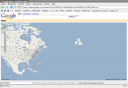
Also, even now, there’s places where Google’s coverage just isn’t up to scratch:
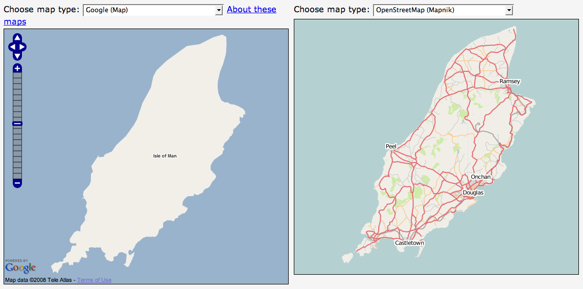
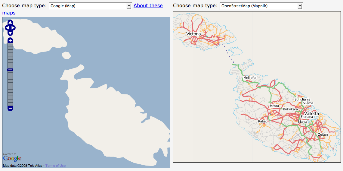
(I must give props to Ed for at least using recent screenshots though, some people have used very out of date screenshots in some of their presentations.)
-
Mate's great band releasing new single
Just a quick one to mention a friend’s band that have a new single out this week. Parka are a great band originating from Glasgow but currently residing in East London. They’ve been around for a couple of years but are preparing for the launch of their debut album with the re-release of their “manic anthem” Disco Dancer. Mark, the keyboard player for the band, used to work for Multimap and I first heard this single just over a year ago. Instantly loved it but at the time it wasn’t available to buy or download (legally).
In December a collection of Multimappers went down to see them play in a small club off Tottenham Court Road. Though they weren’t headlining (they were on second) they were definitely the best band who played on the night and had a good selection of really great sounding songs. I’m definitely looking forward to their debut album but for now I’ll have to make do with the single.


You’ll see a little flash widget thingey on the right which you can use to have a quick listen to the track but I recommend you head over to their website - parkamusic.com - where you can listen to the whole song (it’ll start playing a random track, to hear Disco Dancer keep skipping until it comes up, there’s also a remix which is pretty good too). If you like the track then you know what to do, either follow the links on their website to buy it or head over to disco.parkamusic.com to be linked straight to the shop. They have a special pack of the 7” Vinyl and CD that I’ve gone for, or you can just buy the CD using the link at the bottom of the page. I believe it’ll also be available on iTunes and probably other music download sites too.
Final note, they’re currently finishing off a tour - they’ve still got dates around the country for the next few months - I’m planning to go to their Liverpool gig on the 26th February so if you want to come along and you’re in the area, give me a shout.
-
New version of OSMify bookmarklet
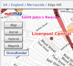
I’ve put together a new version of my OSMify bookmarklet. The main reason for doing this is because the old version is linking to the wrong set of Osmarender tiles; it’s linking to the ones on dev.openstreetmap.org rather than the newer ones on tah.openstreetmap.org. Rather than force you to regularly visit this site and setup a new bookmark every time there’s an update, I’ve decided to host the JavaScript for this version of OSMify on my site.
In the previous version, all of the JavaScript to make the new map types appear was contained within the one line bookmark. This time I’ve put all of the important JavaScript into a separate file hosted at johnmckerrell.com/files/osmify.js. The bookmark now only contains some simple JavaScript required to load that file in.
As well as allowing me to make improvements to the code this also makes the code a lot more readable, allowing you to read through it and understand what it’s doing. If you have any improvements that you’d like to suggest then either drop them as comments on here or email them through to me.
One improvement I did want to attempt was to make OSMify work on other sites than Multimap’s. The Multimap API’s custom map type support works in a very similar way to the Google API so it would be easy to support. Microsoft Virtual Earth/Live Maps also have a method for putting custom tiles into their API. Unfortunately with Google, they don’t expose the full API on their public site (i.e. maps.google.com) so it isn’t possible to add custom map types there. The current version of OSMify will work with third-party implementations, though they will need to expose a global
mapvariable that is of typeGMaporGMap2. I have also had to tell the code to add a newGMapTypeControlafter adding the new map types as for some reason the Google API’s map type control doesn’t update when you add new map types (something the Multimap API does do). I haven’t bothered with Virtual Earth/Live Maps support either yet as I would need to code up my own widget/control for switching between these map types (or tile layers as they call them).So, the link is at the top of this post, have a go with it and let me know what you think. I’d especially be interested in some feedback on using this with Google maps implementations, and any thoughts you have on getting this to work with more APIs.
Technorati tags: javascript, bookmarklet, osm, openstreetmap, map, liverpool, multimap, maps, favelet
-
OS releases OpenSpace API
I was invited to attend a private “hack day” at the offices of the Ordnance Survey on Friday last week for the launch of their new OpenSpace API. A number of other people from the Open Street Map community were also invited (leading to talk of attempts to extinguish the OSM project by doing away with us all!)
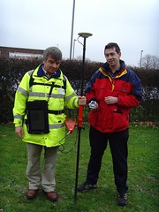 In actuality the guys at the OS were really friendly and had a day of activity planned for us. After the initial introductions we were split into two groups and went off for a mini-tour of how they collect their map data. My group first got to head outside and talk to one of the few hundred on-the-ground surveyors that the OS have. He showed us his collection of equipment, from the low-tech popeye to the 2 metre GPS mast, back-pack full of GPS equipment and the tablet PC for entering new data directly. It was really interesting to listen to his experiences of surveying and to compare it to my own. I’m not sure that he realised that most of those present would consider themselves to be “surveyors”, I’m sure he’d laugh if he heard it though considering the accuracy and quantity of the data that he would collect in an area would be far more than that taken by most OSM mappers.
After this we were taken off to the Photogrammetry department to find out about how OS are using aerial imagery for mapping. OS run two planes, one flying with a traditional film camera and one with a digital camera, to collect their own imagery of the country. They make sure that the imagery they collect overlaps and then use all sorts of advanced processes to convert this into a 3D model - processes such as wearing funny glasses while staring at a screen and clicking the imagery when features overlap. We saw some incredibly detailed imagery - yes, better than google maps - but unfortunately I didn’t get to see their imagery over my house and find my car.
After this mini-tour we were then given a longer introduction to the OpenSpace project itself, their reasons for launching it (a combination of “we want to” and “we had to”) and the terms and conditions of use, which unfortunately turned into an hour long discussion that nearly scuppered lunch! The terms that OS are using have various provisions for deriving data from the maps (which suggested a npemap.org.uk type postcode collector might be allowed) but also don’t allow for commercial usage. After we did finally have lunch we all signed up for the API and started hacking. Here’s what I ended up with, a low resolution plot of my route from London to Southampton:
The API itself is built on top of the existing OpenLayers API. I think this was a really good decision by the OpenSpace team as the world really doesn’t need yet another JS slippy map implementation, and to have a large company developing with OpenLayers, can only help to improve that project. Rather than going with a WGS84 based system though, OpenSpace centres around the use of BNG (British National Grid). Though in theory this is an obvious choice for OS, considering that BNG is “their” system and is the system in which all of their raster based mapping is available (I think), the fact that they require coordinates to be entered using BNG by default is definitely going to lower the number of people that bother to use it.
Though a conversion system is provided by the API, I was interested to find that they are using the algorithmic method to convert BNG eastings and northings to WGS84 latitudes and longitudes, rather than the full National Grid Transformation OSTN02. I’ve never been too sure of the difference in accuracy between these and looking at the page on wikipedia about BNG I find it’s about 7m accuracy for the Helmert datum transformation which I assume they’re using. I guess that’s fine in most cases but Multimap does have a free web service available for doing the more accurate translation, get in touch with me if you want more information :-)
When trying to put together the small implementation you can see above I also came across a few problems that also seemed to arise from the use of BNG. To give you a quick pseudocode run-down, my app basically does the following:
-
Setup data
-
On page load
-
Create new map object
-
Create GridProjection object for converting eastings/northings to lat/lon
-
Create Vector layer for drawing the line between points
-
Loop over the points for my route from London to Southampton
-
Convert position to BNG
-
Create marker at the point
-
Add the point to an array, for drawing the vector later
-
Extend a bounds object to contain the complete bounding box of the journey
-
-
Draw vector
-
Get centre of the journey’s bounding box, and the zoom factor to fully display it
-
Display the map of the journey.
-
I came across a number of problems when I tried passing my converted points into the OpenLayers.Bounds object and an array of the points into my vector. After playing around with it for a while I’d managed to get my markers to display, but not the vector, and the map wasn’t properly autoscaled to my journey. After looking at the vector example though I noticed that they were passing OpenLayers.Geometry.Point objects into the vector, and OpenSpace.MapPoint objects into the setCenter method. This is quite possibly a problem with OpenLayers rather than with the OpenSpace implementation, though I can’t be sure either way. After a little playing around though I found that adding the following line of code, then using the
pointvariable with the bounds and vector objects fixed my problems:point = new OpenLayers.Geometry.Point( mppoint.lon, mppoint.lat );So, conclusions: I have to say that I don’t think that this API is ever going to change the world. There are so many mapping APIs out there that are freely available anyway that this one is just not going to have that effect (especially with Multimap offering the same landranger 1:50k data, in a WGS84 environment). That said though, I can see definite uses for it in the UK, and I know that many UK based organisations will be happy to use the BNG system. It also means that Ordnance Survey are going to be meeting their mandate to promote the use of their data and noone can say anymore that there’s no way to get access to Ordnance Survey data free of charge (or at least when the API is available outside the current closed release anyway). There may be lots of restrictions on use at the moment, but at least it’s something and hopefully this small step will lead onto a lot more open-ness at the OS. Also I definitely don’t want to put down the guys that have been working on this, what they’ve achieved is great, they just need to keep working on it, and working on the people above them to allow more data and more freedom of use for the data.
-
-
Simple Static Maps API, similar to Google Charts
I’ve been subscribed to the 24 ways feed again this year. They’ve had some really interesting stuff I might make use of sometime such as the Javascript Internationalisation and Neverending Background Image articles. Today’s article on the new Google Charts API reminded me of something I thought of last week when the Charts API launched. Multimap have recently launched a new way of accessing their maps API which I think is actually pretty similar to the Google Charts API in some ways. The new static maps API is an incredibly simple way to insert a map onto your pages without having to write any actual code, it allows you to put maps on pages that you don’t expect your users to hang around on for long and they’re great for using with mobile devices.
The Multimap Static Maps API is similar to the Charts API because to get a map all you need to do is put some parameters on a URL, you can get a map with a single
qs=[postcode]parameter. A big difference is that you do have to sign up for an API key. This isn’t too difficult though, you’ll need to register for “My Multimap” then head over to the Open API Signup page to get your key. Once you’ve done that you can use this key to access the JavaScript API as well as the new Static API. You also must provide a link on your page to the terms of use.So, let’s get cracking shall we? Here’s a map featuring Multimap’s office on Fleet Street in London, the postcode for it is EC4A 2DY so I’ll just use that:
http://developer.multimap.com/API/map/1.2/[api_key]?qs=EC4A+2DYIf I’m going to give you lots of examples, I should probably trim that image down a bit, maybe make it a bit wider, but shorter. I think I’ll also change the label on the marker, in fact I’ll just get rid of it for now, how does this look?
http://developer.multimap.com/API/map/1.2/[api_key]?qs=EC4A+2DY&width;=450&height;=300&label;=+When passing in geocode search parameters or marker labels be sure to URL encode the strings, the Javascript function
encodeURIComponentis good for that. Also note that I passed a single space into my marker to give it a blank label.I think it would be good to display some landmarks on the map too so that you have an idea of whereabouts Fleet Street is in relation to, say, Saint Paul’s cathedral, Buckingham Palace, The Houses of Parliament and the London Eye, so how’s this:
http://developer.multimap.com/API/map/1.2/[api_key]?width=450&height;=300&labels;=+,1,2⪫_1=51.51428&lon;_1=-0.10823⪫_2=51.51373&lon;_2=-0.09901⪫_3=51.50182&lon;_3=-0.14061⪫_4=51.49917&lon;_4=-0.125⪫_5=51.50383&lon;_5=-0.11972-
Multimap’s Office, Fleet Street
-
Saint Paul’s Cathedral
-
Buckingham Palace
-
Houses of Parliament
-
London Eye
This is all very UK-centric though and it would be a shame to ignore the great mapping that Multimap provides around the world, so how about we do a bit of shopping in New York? We’ll hit a few of the big shops first then head somewhere a little more affordable to get a few things for ourselves:
http://developer.multimap.com/API/map/1.2/[api_key]?width=450&height;=300⪫_1=40.74982&lon;_1=-73.98954⪫_2=40.76221&lon;_2=-73.96821⪫_3=40.76266&lon;_3=-73.97395⪫_4=40.74225&lon;_4=-74.00426⪫_5=40.73986&lon;_5=-73.99497-
Macy*s Department Store
-
Bloomingdales
-
Tiffany
-
The new Apple Store
-
Old Navy
And finally to get things even more international how about all the places I’m lucky enough to have travelled to this year (largely due to weddings/honeymoon):
http://developer.multimap.com/API/map/1.2/[api_key]?width=450&height;=300&qs;_1=Liverpool⪫_1=53.41667&lon;_1=-3⪫_2=9.4759&lon;_2=99.9566⪫_3=22.32341&lon;_3=114.21175⪫_4=39.9045&lon;_4=116.391⪫_5=36.71963&lon;_5=-4.41991⪫_6=41.066&lon;_6=29.0061These are just some of the things you can do with the static maps module, take a look at the full documentation for more examples. I’m hoping that we’ll get quite a few people using this, it’s a really good way of getting a map onto a page without requiring the larger payload of a full JS API. If you do make something then why not put a comment on this page, maybe you could do a map of all the places you’ve been in 2007?
Technorati tags: staticmap, charts, google, multimap, map, api
-
-
Visiting Yahoo!
I paid a visit to the Yahoo! offices in London last week, having been invited to a “Yahoo! Developer Summit”. I was intrigued to find out what was going to happen at this “summit”, especially with 3 days allocated for it. I had assumed it was going to basically be a mini-conference with a mix of Yahoo! employees and outsiders attending. As it turned out it was basically an internal Yahoo! event with talks covering various topics, generally “web dev” related, to which a small number of external people had been invited.
Unfortunately, being pretty busy in work I was only able to attend on the Wednesday and some of Friday, but I still got to see a good range of talks. In fact the range of topics was pretty broad and not particularly Yahoo!-centric at all. I attended talks on “web security and XSS”, “High Performance Web Sites”, “Using Bazaar for Version Control”, “Working in Distributed Teams” and “Writing Engaging Tutorials”. There was also a great keynote from Simon Willison on using comet server push technologies, something I’m definitely going to use in the future.
I also have to mention the pub quiz that ended the summit. As Jeremy has mentioned we outsiders banded together to fight off the Yahoo! hordes. Apart from my absolute insistence that Firefox 1.0 was released on 19th December 2003 (I was thinking of the date of the New York Times advert, but got it wrong by 3 days and 1 year and the release actually occurred a month before anyway!) we still did pretty well coming in third, as Norm had said from the start “if you win, that means you’re the biggest geeks” so I’m glad to say our coolness held us back from that first place spot. I still got to choose a selection of Yahoo! merchandise to take home from which I took a delightful YDN t-shirt and an “Insta-Yodel!” (which I donated to SteveC at the OSM xmas party and he had lots of fun with).
So all-in-all I have to say I enjoyed the event, it was a shame I couldn’t make it to the whole thing, but 3 days was just too long to be out of the office (especially when Internets were in short supply at Yahoo!) I’d happily go along if invited again, hopefully Yahoo! will open it out to more people in the future too. Talking to some of the Yahoos there did seem to be a feeling that they should be doing more in the general community. I know that we at Multimap also want to get more involved in the web dev and mapping communities more in the future too so perhaps we can find a way to arrange a combined event in the future.
-
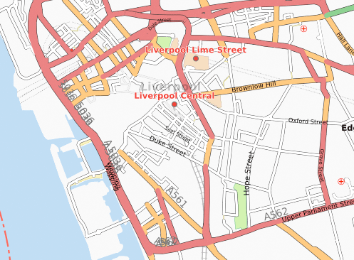
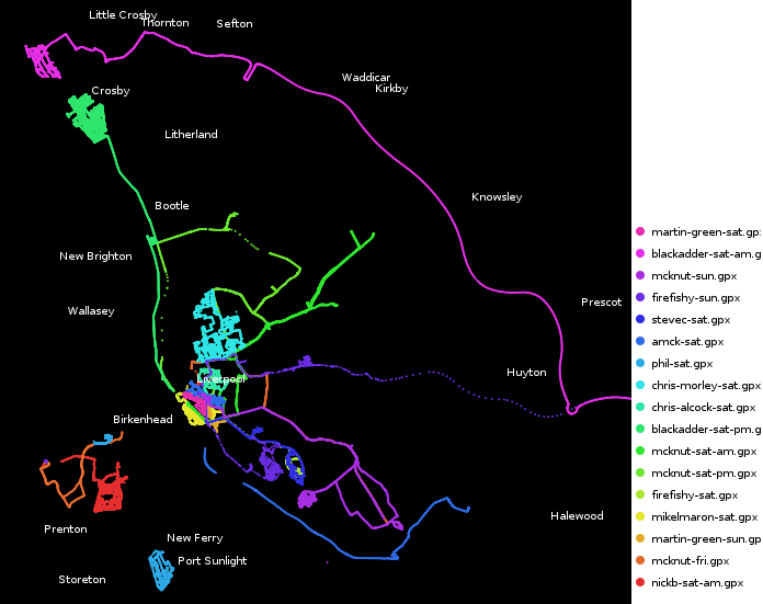
First Liverpool Mapping Party a Success
We held the first Liverpool mapping party over the weekend and I’m glad to say it went pretty well. Though we didn’t get as many new people turning up as we would have liked, we still managed to cover quite a lot of ground. Our main target for the weekend was to get as much of the centre of Liverpool mapped and it looks like we managed to achieve that aim. There’s still a few areas towards the North West that need finishing off, and the Paradise Street Project still needs to be marked as “under construction” somehow, but we’re basically there for central Liverpool as you can see from this animation:

We also had people out mapping in other areas of Merseyside, Crosby got it’s first detailed OSM coverage, as did Birkenhead and Everton. Aigburth also saw numerous improvements including some path mapping in Sefton Park.
I have to say a big thank you to the guys at Glow New Media for their support, not only did they let us use their office as a base for most of Saturday, but they also provided breakfast and lunch! We also have to thank Rightmove for providing drinks and food in the evening.
We’re already planning the next party which we’re hoping to hold in January 2008. We should be able to get a dedicated space to use for the party to allow people to come and go more freely, and we’ll be advertising this one a lot more to try to get new people involved. I’m sure I’ll be blogging about it as soon as I have more information about that.
I’ll finish off by thanking everybody who came, it was great to see some people who hadn’t mapped at all before, and it was good to have lots of established mappers in attendance to help them out. I know some people travelled a long way just to help us out in Liverpool which is really appreciated. So, finally, the obligatory image showing all of our traces:
Click on image to see key
Technorati tags: liverpool, liverpool0711, osm, openstreetmap, map, maps
-
Recent Mapping Activities
I thought it was about time I mentioned mapping in my blog again. I’ll start by mentioning a recent development with the Multimap Open API. Expanded UK data coverage is now available which should enable a lot more interesting UK mashups. The article mentions in more detail what is now available but basically you can use Ordnance Survey Landranger maps together with full UK postcode lookups. I’m really hoping that this will get people excited enough to knock up some cool demos. The blog posting over on blog.multimap.com shows an example plotting a trace from when I took five multimappers off walking in the hills of Wales, but I’m sure there’s a lot more that can be done (geocachers are you listening?)
My second link is actually about something that Microsoft have done using the traffic logs from their Virtual Earth (Live Maps) traffic logs. It’s been a few weeks since the link was posted but I wanted to also link to a similar thing that was done using Open Street Map traffic data. You can also view stats on the 10 most popular tiles from the innovative “Tiles@home” project (scroll down the page, or search for “Popular areas”).
Arbitrary Map of Liverpool, see below for explanation
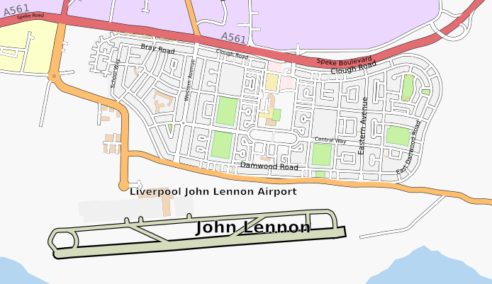
Finally I should mention that I’m organising an Open Street Map mapping party in Liverpool in a few weeks time. Venue is yet to be confirmed but the date has been set to the 10th and 11th November (2007). You can visit the OSM wiki page for Liverpool or the event page on upcoming.org for more information. Liverpool’s coming along really well but there’s still plenty more to be done, hope to see you there!
Technorati tags: osm, openstreetmap, maps, mapping, liverpool, merseyside, ordnancesurvey
-
Wedding and Honeymoon Over, Married Life Begins
 After taking numerous attempts to write this blog post and going into far too much detail I’ve decided to trim it down to a few paragraphs, I’ve got a few other ideas for posts but really should get this one out first!
First, the wedding. The day went really well and surprisingly smoothly. Everybody that we’d picked to help us out with our wedding was brilliant and helpful. About the biggest problem was the DJ (hired via an agency) but then it’s no big surprise to hear of a wedding DJ playing crap music. Apart from this the day was amazing, it was just great to be able to get all of our friends and family together and have a big party. It’s also great these days that with the wonders of modern technology we managed to see lots of photos taken on the day before we even went on honeymoon!
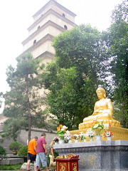 Secondly, the honeymoon. We spent an amazing three weeks touring around China (Beijing, Xian, Guilin), visiting Hong Kong, and lazing on a beach in Koh Samui, Thailand. The culture and heritage in China was incredible, and our guides were really good at telling us all about it. Hong Kong was smoggy and cold (air conditioning!) but still an interesting place to visit. Finally Koh Samui was just a really nice place to relax for a week.
We travelled on 9 flights on our trip (going to and from the far east via Dubai) and apparently used 7 tonnes of CO2 to do it. Fortunately that’ll only cost us about £50 to offset apparently so we’ll probably do that soon. We used 4 currencies and needed 3 visas but it was all worth it for the great time we had, evident in the 830 photos that I took (select few now showing on flickr!)
So, I’ve kept this short, but if you’re interested in hearing more about the honeymoon then just drop me a line or ask me when you next see me. I’ll end this blog post in the only way appropriate by saying: my wife and I thank all of our friends for helping us make our wedding day go so smoothly and for helping us have such a great time.
-
Wedding Day Imminent
As usual I haven’t really been blogging much recently, and when I do it’s usually about some tech subject or other. Something that’s not particularly techy, but a pretty big event for me, will be occurring tomorrow though and I thought I really should put some mention of it up here. I’m getting married!
Pretty much everything is arranged now, though there’s still lots of jobs to get done today and tomorrow morning to make sure everything runs smoothly. As you may have seen from my twitter stream, we got the rings and the rest of the suits yesterday. Today we need to do some last bits of shopping for our honeymoon, we thought some new luggage might be useful, and then I need to start transporting stuff over to the hotel that we’re holding the event in. My fiancé obviously has all sorts of girly jobs to do, such as picking up dresses and getting her nails done and getting all her family together in our house.
In good tradition, I’m spending the night elsewhere - I have a lonely little single room in the hotel to keep me company. Fortunately half the wedding guests will be staying there too so it shouldn’t be too bad :-) Tomorrow there’ll be lots more jobs, making sure the hotel is all ready for us, and distributing the corsages. I’ll probably end up having to make sure everyone has transport to make it to the church and back too, but that shouldn’t be a big problem as there’ll be lots of cars around. After that there’s something about standing in front of a crowd of people and saying something along the lines of “I promise to give you all my money”, or something along those lines…
Well, my fiancé’s calling so I think I have some jobs to do. I’ll probably update my twitter feed if you’re interested in what’s going on, hmm.. and sometime I’ll start my speech.
subscribe via RSS or via JSON Feed