-
Week Notes Week 86
Last week I was intending to spend on all mapme.at, all the time. Things didn’t quite work out so well but I did get some stuff done. The week started slowly as I procrastinated due to jet lag and generally not feeling like getting back to “work” after my holiday. Most of Monday was spent catching up on the bits of client work that had come in during my three weeks away, I also booked in a full day of client work on the Thursday to sort out some problems a client was having.

Tuesday I decided to take a trip into town and debug the problems we’ve been having with the Mersey Ferries on mapme.at. For some reason their positions haven’t been updating on shipais.com and I wanted to see with my own eyes that they were running. Soon after I got to the ferry terminal Royal Iris turned up to confirm that they were running fine. I decided not to pay for a trip myself so that I could talk to the skipper, good thing too as when I got home later in the afternoon I found they’d randomly started working again that morning!
On Wednesday I finally got going with some more work on mapme.at. First thing I needed to do was fix a problem that was causing duplicate places to show up due to the recent updates. Currently when a user looks at an area and they’re zoomed in enough I always download data from cloudmade, de-dupe it against data I’ve already cached and then add any extra records to my database. Cloudmade provide their own IDs for their results and I had assumed that these would be unique, I had also de-duped against the OSM IDs but a bug in that code had stopped it from working. It turns out the IDs provided by Cloudmade change (every time they do an OSM import I’m guessing) but they’re also unnecessary for my purposes - I will only use a result if it has an OSM ID anyway - so I’ve switched to de-duping on the OSM IDs only and everything seems to be working now.
I also started working on integrating Facebook Connect. I want to make it as easy as possible for people to get going on mapme.at, especially if they’re using a mobile app, and I think a good way to do this is by using Facebook Connect as most people are going to have an account on Facebook. I found it quite fiddly to get going with Facebook Connect, it seems to require JavaScript which I wanted to avoid, and there’s a variety of Ruby libraries with no real consensus on which is best. I ended up using Facebooker and following this tutorial which pretty much sorted me out. Watch out for the bug on that page though, you need “before_filter :create_facebook_session” not :set_facebook_session.
On Friday I got most of the Facebook work finished, on my development version I can now attach a Facebook account to an existing mapme.at account and use Facebook Connect for login and signup. I haven’t pushed it live yet as I want to improve the signup process a little but it’s definitely getting there.

This coming week I’ve got a trip to London (today) to talk about some more client work but hopefully I’ll get some more stuff done on mapme.at today. I’m actually hoping to get GPX file import working so that I can have a lot more data for visualisations for my Where 2.0 talk. That’s also going to be the main thing I’ll be doing this week, trying to get my talk completed and ready for handing over on Friday!
-
First WhereCampEU - Definite Success
 WhereCampEU was this past weekend and by all accounts it was a blast! In case you don’t know, WhereCamp is based on the BarCamp model meaning that it’s a conference which is free to attend at which anyone can speak. The schedule is blank until the day of the conference when any of the attendees can announce their talk by putting it on “The Wall”: a big grid drawn out using masking paper allowing you to choose a time slot and a room.
It may have started out blank but the schedule was packed with great talks by the time the conference got going. I tried to go to as many as possible but, especially on the first day, many of the rooms ended up full to bursting. I was also tired because I’d just got off a 24 hour flight from Sydney so I did end up missing a few slots. Harry’s already posted photos of the wall and the talk titles have been copied onto the wiki, now it’s just up to the speakers to add some info about their slot (I’ve only just done mine).
The first talk I went to was about “GeoPrivacy, Your thoughts”, a discussion introduced by Chaitanya. It was interesting but most of the discussion was about privacy on the internet generally, rather than specifically location privacy which interests me most. I later caught the end of the Pedestrian routing talk as they came to the conclusion that for ideal results it really would depend on the user (a young female is likely to want to walk down different streets to an older male, probably). I also found a talk about using Apple’s iPhone “MapKit” library quite interesting as so far I’ve only used the route-me library. It also gave me the opportunity to plug my LocationManagerSimulator code. There was a few talks around the concept of “place” too, with my recent switch on mapme.at to using “places” these were quite interesting.
The evening involved geo-beers kindly sponsored by Axon Active:
Day two started for me with my own talk on Hacking Location into Hardware. I had intended to discuss my “Weasley Clock” a little and talk about how it worked. In the end I think I just rambled on too much and probably didn’t actually help people to understand how either the hardware or the software was put together, but hopefully I was entertaining at least.
I actually quite enjoyed the talk titled “A little light relief. Using global terrain data in your maps”. I only really attended because it promised light relief (and I only just got the pun today!) and because it was being given by an old colleague - Simon Lewis but it ended up being quite interesting and inspired me for some visualisation I need to do soon. The talk covered various aspects of Simon’s attempts to add terrain and relief shading to maps using a selection of open source tools.
I have to mention that one of “my” biggest contributions to the event was actually the logo, which I asked a friend to produce. Though I knew the logo was good originally it looked really great when printed out and mounted on posters, t-shirts and blog posts so I’ll definitely thank Sophie Green for producing that. I’ve used her for my mapme.at business cards before and always been happy with the results.
And there’s more geotastic geogoodness to come with Where 2.0 in two weeks. I will be talking about my experiences of tracking my location for the past few years in a session titled Why I Track My Location and You Should Too. It’s based on the session I’ve given at a few events already but should have fully new material. Maybe this time I’ll actually answer the question of “why?”, but more likely I’ll just show more pretty visualisations and hope no-one notices!
-
Week Notes Week 82
Just got back from a three week holiday to Australia and Singapore (well, in fact I still haven’t actually made it back, I’m on the train home from London after WhereCampEU!) Most of this was written on the train to Heathrow on the 19th February, unfortunately I didn’t really get time or sufficient internets to post it sooner. Hopefully next week’s will be up faster!
Another busy week as I prepared for my holiday which I’m now on! As mentioned last week my focus was supposed to be finishing off the mapme.at features while also mopping up the scraps from the client work I’ve done recently. I also ended up with a new day’s worth of client work which I’d quoted for a few weeks ago but forgotten about. I had finished the bulk of the client work that I’d been planning by Tuesday lunchtime but annoyingly I did find it kept springing back as my numerous related tweets will show. I had hoped that with all this “just one more thing” that someone might have paid me before I left, but alas no.
But enough about client work. The “place based check-ins” for mapme.at that I mentioned last week came along really well and I managed to get the code live on Wednesday (17th February). Since then there’s been a few tweaks here and there but as far as I can tell it all went out without any major problems. I put a blog post up about the changes so take a look at that for more information on those.
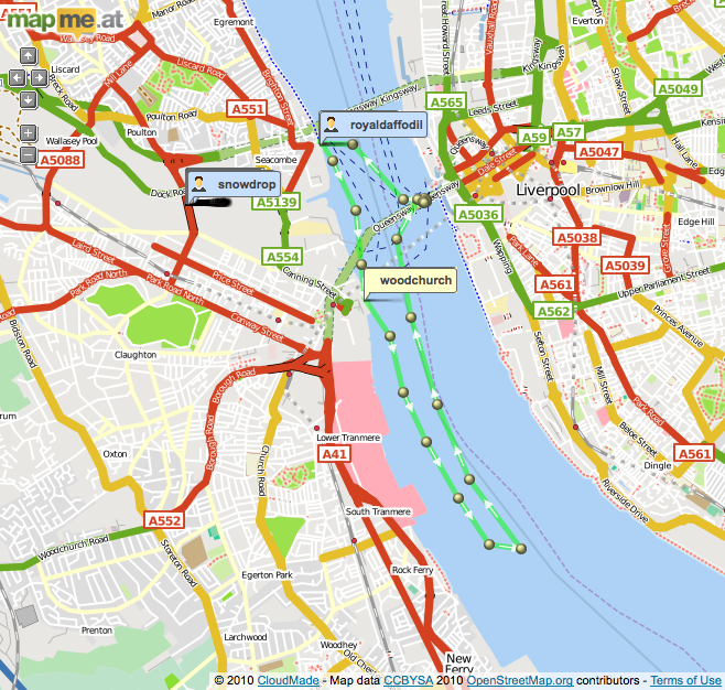
Something I forgot to mention from lunch last Friday was that Adrian McEwen asked me if I would like him to take my Weasley Clock to Maker Faire UK. Adrian was there last year and his famous Bubblino was filmed by the BBC. Maker Faire is all about interesting hardware hacks and so my clock should definitely be welcome there. Unfortunately it’s on the same weekend as WhereCampEU so it’s a good thing that Adrian offered to take the clock for me. I’ve wanted to come up with something better for it to show than my location as, even with my current travels, it tends not to change much over the course of a few hours. Something more interesting would allow me to demonstrate the clock more actively at conferences. Adrian suggested we use the mapme.at accounts for the Mersey Ferries so I made a few changes and got the clock showing that.
There’s three ferries but usually only one or two of them are active so the 2 hands of the clock can be utilised. When on their standard route the ferries travel between 3 ports - Liverpool, Seaforth and Woodchurch. Other than that they tend to either be in open water or moored in the docks. Using the new place-based functionality I was able to make sure that all the ports and mooring points were in as favourited places with labels for all the accounts. I then updated the clock’s Arduino code so that it could handle 6 different locations (instead of the existing 4). It seems to be working ok but unfortunately before I handed the clock over to Adrian the ferries didn’t seem to go anywhere. I’ve only described 5 of the 6 “places” so far… I took the opportunity with the redesign of the clock face to add a “Mortal Peril” option which should now occur when the ferries are doing tours down the Manchester Ship Canal!
Now I’m back from my holiday I’m sure I’ll have to spend some time over the next few weeks sorting out client requests that have come in while I’ve been away but I’m really hoping to get some more time to work on even more mapme.at features. I’m speaking at Where 2.0 in two weeks and so need to get a talk written with some good visualisations, and want to have a few products I can announce too.
-
Week Notes Week 81
I tend to ignore blogging trends, in fact I wouldn’t really go as far as to call myself a blogger, but this “Week Notes” trend could help me to work better and more efficiently so I thought I’d give it a go. The week numbers run from the time at which the company was incorporated and MKE Computing Ltd, the limited company I set up to handle my freelancing work, was setup on the 30th July 2008, hence week 81.
This could actually be the worst time for me to start something regular considering I’m actually going on holiday at the end of this week, but what the heck, it’s some content for my blog if nothing else!
So this week has been pretty busy, largely as I’m trying to wind things down for my holiday. Monday and Thursday afternoon I was in the offices of Moneyextra.com where I regularly do a few days work. My work there is generally PHP though has ranged from Perl through VB.net through to an iPhone app in the past. At the moment I’m working on a PHP-based back-office system that they’re doing for Carphone Warehouse. It’s actually based on OSCommerce which I think was last developed in 1973 (honestly, it feels that way) so is really outdated and can be a pain to extend.

My main focus this week and next was actually supposed to be to get lots of work done on my “start up” website mapme.at. I’m giving a talk at the end of March at the Where 2.0 conference and I’m really hoping to have some interesting things to talk about. The main things I was supposed to be doing is developing two iPhone apps to work with the site. One is focused around putting data in, the other more focussed on pulling it out in a unique and fun way. I’ve been having issues decided how to handle authentication though. If I put an app on the app store it’s quite likely that most people who download it have never heard of the site and won’t have an account. I’d like to do something really simple to handle creating an app, potentially even doing it silently in the background. I already use OAuth for the API and it would be possible to handle a signup step as part of that but the OAuth process is quite jarring to many users (the app has to quit, Safari launches and then you have to be sure to reload the app when the signup/login and authorisation has finished). One option would be to use Facebook Connect and automatically create a user linked to their Facebook credentials, this could also be confusing to many users and would require me to integrate facebook connect into mapme.at in general. I think I’ve decided to just stick to the OAuth method for now and to look at improving it once I’ve got an app that I can demo.
As part of looking at authentication though I decided to improve my existing OpenID support. My initial implementation was done in such a way that you could attach the same OpenID credentials to multiple accounts. I guess I thought that might be a useful feature but I think most people found it annoying as it meant that to log in, you had to enter your OpenID and your username, as mapme.at wasn’t using the OpenID as a unique identifier. I’ve now fixed this which should hopefully make things simpler. I’m also intending to reduce the number of fields you need to enter to create an account, but again I think I’ll wait until I’ve got some iPhone apps I can demo.
Something else that I’ve been considering for mapme.at and decided to implement this week is “place based check-ins”. Currently on mapme.at you either map yourself at an arbitrary latitude and longitude, or you create a “favourite” location and map yourself there. There was a few “global” favourites which I had added myself but generally you had to create a favourite manually or use some sort of logging app or API to log your location arbitrarilly. The new functionality means that mapme.at will give users access to a big database of existing shared places. This database, and improved UI on the site, will make it much easier to say “I’m in the supermarket” rather than “I’m at 53.415812,-2.921977”. I decided that having that functionality in place would vastly improve one of the iPhone apps so I decided to start working on it. It’s coming along really well, there’s still work to do but I think I’ll have it out in just a few more days.
On Friday I met up with some old friends, and met some new ones, for lunch. I had a good time and it was good to catch up and find out what others are up to in Liverpool but it did cut into my dev time on the new functionality.
Next week I’m hoping to spend at least another two days working on mapme.at. I’ve got some functionality to finish off for another client on Monday but apart from that it should be mapme.at until I got on holiday to Australia at the end of the week!
-
Basic Sat Nav and LocationManagerSimulator

I’ve just launched an awesome new iPhone app - Basic Sat Nav. A PND/Satnav app for your iPhone that will direct you anywhere in the world. Using Cloudmade’s great geocoding service I can provide essentially global coverage that no other iPhone satnav offers. Okay it doesn’t have advanced features like “Augmented Reality”. In fact it doesn’t have any of the more basic features like “turn by turn directions” but I think there’s nothing better than a series of textual updates telling you whether you’re getting “Hotter” or “Colder” for getting you where you need to be.

Ok, so maybe it’s a bit of a joke but I’ve been amused that everyone who’s seen it has paused for a moment and then said “cool! that would be useful for X”. The most obvious thing that people have asked for is Geocaching support so I may try to add searching for geocaches in the future, I’ll see how things go though as I really want to avoid feature bloat.
Testing a satnav really isn’t the simplest thing to do though. When testing iPhone apps in the iPhone SDK provided iPhone Simulator you get a single location update that puts you in Cupertino. This is obviously completely useless when writing a satnav. To get around this I wrote a new LocationManagerSimulator class that I could add to my project which will take in a Property List file (converted from a GPX file recorded earlier) and will replay the locations in that file every time I start the app. This was a really good way of testing things – so long as I had a well defined route in my GPX file I could then search for a location along that route and the sat nav would update as my recorded position got closer and closer to the destination. If I picked a location halfway along that route I could see the satnav updating as I got further from the destination too.
The simulator will take the HDOP and VDOP values from within the GPX file and will, using a simple metric (× 6) convert these to horizontalAccuracy and verticalAccuracy values. If they’re not present it uses fixed values of 50.0m for these fields. If there’s an “ele” field in the GPX then this will be used for the altitude, otherwise altitude is set to 0m. Currently the code is pretty basic but it does all that I needed it to and should be quite easy for others to use. Simply drop the two files (LocationManagerSimulator.h and LocationManager.m) into your project and change your reference to CLLocationManager to LocationManagerSimulator. If you have a file named
simulated-locations.plistin your project then it’ll read from that by default. Otherwise you’ll want to use the full initWithFilename:andMultiplier: call, this also allows you to pass a multiplier so that the route runs faster or slower. Simulate a driving route on your bike or vice versa!I want people to just go ahead and use this so I’m putting it out there as public domain/CC0 or whatever you need to be able to use it without worrying :-) You can download LocationManagerSimulator from github where you’ll also find a bit more documentation. If you feel guilty about using my code for free then please do buy Basic Sat Nav from iTunes. If you have ideas for improvements then let me know or, better still, fork the project and add them yourself!
Oh, nearly forgot to say, if anyone wants to try Basic Sat Nav out for free then I’ll give promo codes away to the first 20 people that ask in the comments. Unfortunately promo codes can only be used in the US iTunes store though so only ask if you’ll be able to use it!
-
OSM State of the Map and AGI Geocommunity
So one of the great events that I’ve, er.. delayed writing about was the annual OpenStreetMap conference “State of the Map”. This year it was a 3 day conference (previous years had been 2 days) with the extra day accommodating the various commercial people that have started making use of OSM data. It was a great idea to bring in some fresh faces to the conference and actually gave me my first speaking opportunity of the weekend, talking for five minutes about mapme.at. The following two days took a more traditional course with various members of the community talking about the ways in which they are using and working with the OSM data.
A selection of countries gave a “State of
" type talk, these are always really great to hear, especially for the smaller countries where perhaps Internet access or access to GPS technology is not so great. Often in these locations there isn't even any existing map data so there's a great opportunity for the OSM community. The talks from Pakistan and Brazil were particularly memorable and were only made possible due to the great OpenStreetMap Foundation "scholarships" program which was a great way to make sure we had attendees from all areas of the world. It was also good to see these attendees being handed GPS devices as part of the [GPStogo](http://wiki.openstreetmap.org/wiki/GPStogo) program which hopefully they'll take home and use to collect many more GPS traces.  The OSMF Scholarship attendees
The conference took place this year in Amsterdam and it was my first time visiting the city, though I didn’t see much of it in the first few days while at the conference we fortunately stayed on (we being my wife and I) to spend another few days in the city for some rest and relaxation. We had a great time there and I had plenty of opportunities to use my (still relatively new at the time) DSLR camera as you should be able to see from the photos scattered around this post.

I managed to make it three years running speaking at a SOTM conference not only with my 5 minute segment about mapme.at but also with a full half hour on Saturday afternoon talking about OpenStreetView. This is my idea for a project to try to create an openly licensed database of street-level imagery, and ideally some really impressive software to go with it. The talk went well though I had an “interesting” Q&A; session afterward, obviously people are still concerned about the privacy aspect even when related to what I hope will become a very open project. Unfortunately at the time I hadn’t completed the software side enough to launch the project, and as you may have noticed I haven’t yet launched it, more on that soon.

Next week I’ll be attending another conference, and again will be speaking about OpenStreetView. Ed Parsons has written about the conference that he “was disappointed with the introspection and backwards thinking demonstrated … and had all but given up attending” which doesn’t sound like a big vote of confidence. The conference is AGI Geocommunity and fortunately a big effort has been made by Stephen Feldman, Chris Osbourne, John Fagan, Rollo Home and many others to improve the situation leading to a really great and interesting looking programme.

As mentioned I’ll be speaking about OpenStreetView again, but this time I’m intending to have something launched and usable beforehand. It won’t be particularly pretty, it won’t have a huge number of features, and it probably won’t have a huge database of images, but I’m hoping this will all change once I open it out and get more people involved. My aim with the project is to build a database of images and metadata which can be built upon by others who are already working on the software side for viewing these things. It should also provide a home for imagery being created by various people who are already building hardware solutions for collecting it. Unfortunately (for the project, good for me) I’ve been very busy over the summer with paying clients but I’m hoping I can get things finished off this week to allow upload and moderation, then the fun can begin!
I also can’t talk about conferences without mentioning another speaking date I have coming up in November. While the AGI is a national group aimed at representing the interests of the whole UK’s geographic information (GI) industry, they also have smaller groups aimed at bringing together the GI community in different areas. The AGI Northern Group achieves these aims in the North of England with a monthly meeting and this year their first full-day seminar - the AGI Northern Group Where2Now Conference. It’s being held on the 10th November in Harrogate and I’ll be speaking along with a great list of people. Ticket information isn’t yet available but put the date in your diary, check out the linkedIn events page and head over to Tim’s blog for more information on the speakers.
If you’re going to the conference next week and we haven’t met before then please do say “Hi!” I’m really looking forward to it, not just for the great content on offer but also for the opportunity to meet up with some old friends that I haven’t seen in some time, and also to meet some new faces. I’ll close this blog post out though by quoting Tim Waters and his write-up of the SOTM conference, it’ll be interesting to see if the AGI Geocommunity conference can generate just as much emotion:
Yes, I got a bit emotional at the third OpenStreetMap conference, held in the CCC, Amsterdam last weekend – mainly because this globe we are on is the only one we know – we really are mapping our universe, doing it our way. Creating the world we want to live in. [Tim Waters](http://thinkwhere.wordpress.com/2009/07/15/were-making-the-world-weve-always-wanted-to-live-in-sotm09/)
-
YUI Flash Uploader crash in Firefox
Ok, so I’m still not blogging about future and past conferences but I had to post about this one as I’ve just wasted an hour trying to fix it.
I’ve used the YUI Uploader a few times now as a handy way to upload multiple files. In my current project I’m using it mainly as an Ajax uploader, I need to upload multiple files and create a variety of DB records in a few Ajax requests so I thought this would be a good way. Initially I had a few errors because I was getting a 401 - the flash doesn’t pass the cookies through. I sorted this out by passing them in the URL (and modifying the PHP to read $_REQUEST as well as $_COOKIE). I then tried in Safari and found the flash element had zero height so wasn’t accessible. Played around with the CSS and got it working. It was successfully uploading the file but for some reason not calling my JavaScript function callbacks. Oh well, bit odd, let’s try Firefox again. Tried it and Firefox crashed! I then spent an hour trying to figure out why Firefox was crashing.
One thing to mention before I tell you why. The YUI Flash uploader has to get around a limit in Flash 10. The actual process of launching the “Select Files” dialog must come from within the flash. To achieve this you either give the flash the URL of an image or you position the flash on top of some HTML, I was going with the latter, hence my problems when the flash had zero height.
Because my save process involves the flash file uploading and a few ajax requests I had decided to hide the flash during this process, to make sure that during the ajax requests a user couldn’t try adding new files in. I did this by adding “display: none” via a CSS class. This is what was causing the crash in Firefox. It seems that giving the flash “display: none” was detaching it from the page (or something), Firefox didn’t handle this well and so crashed out completely. Safari handled it a bit better, it didn’t crash but my function callbacks were no longer attached.
So, moral of this story, don’t “display: none” your YUI uploader flash. I’ve tried setting “visibility: hidden” and that works equally well, without causing a crash. After spending an hour fixing this I decided I had to post something to try to save someone else that pain, I didn’t see anything similar in my googles of “flash YUI crash firefox”.
-
Helvetireader
I need to blog more, like seriously, for now though… I use Google Reader to read everyone elses blogs. I use it a lot so I was very interested to read on twitter and lifehacker about an extension thingy to allow you to view a nicely restyled version of Google Reader that uses the Helvetica font to give a much nicer experience, Helvetireader. The only ways to use it though is using a userscript that requires Greasemonkey or Greasekit, or a user CSS if your browser supports it. I generally use Safari and don’t have Greasekit installed so didn’t have an option to quickly try it out, so I knocked up a bookmarklet. Add the following link to your bookmarks (I generally put these in my toolbar/”Bookmarks Bar”), then when you’re in Google Reader click on the link and it’ll switch you to Helvetireader. If you don’t like it just refresh the page, if you do then you can look into one of the other options, or just keep using the bookmarklet.
I promise I’ll blog more soon, I’ve got two past conferences and two future ones to tell you all about!
-
Hacking Location into Hardware
UPDATE 2011/11/16: It’s now possible to buy a mapme.at WhereDial “Weasley Clock” just like this one!
Last weekend I went to the Howduino hack day which by good fortune was happening on my doorstep, in Liverpool. The day was organised by two friends of mine - Adrian McEwen and Thom Shannon - who have been doing hardware hacking for quite some time now and wanted to open things up for more people to get involved.

The day was partly named after Arduino (with a bit of Scouse humour mixed in - “how do we know?!”). From their website:
Arduino is an open-source electronics prototyping platform based on flexible, easy-to-use hardware and software.
Basically you get a circuit board that has a USB slot, a power slot and a set of digital and analogue inputs and outputs. You can load software onto the circuit board via the USB slot, the software can then run on the board when it is disconnected from the computer and can operate other hardware through the inputs and outputs. Adrian used one of these devices to make the famous Bubblino twitter monitoring bubble machine and the Mazzini power monitoring project. Thom has used it to make, amongst other things, a light tracking mini.
Though Howduino got its name from the Arduino boards, the day was actually more of a general hardware hacking event. Sophie Green spent most of the day making artworks using “brush bots” which were incredibly simple devices made from motors and batteries mounted on toothbrushes. Some people built a “drawbot” from scratch on the day and a few people tried making racing radio controlled cars with movements controlled by twitter hashtags.
My project was suggested by Grant Bell, he thought that I should use mapme.at to create a “Weasley Clock”. This clock is described in the Harry Potter books by J.K. Rowling, it is used by the Weasley family to see where each member of the family is. Instead of telling the time, each hand shows a photo of one of the family members, the clock face has a number of locations written around the edge, such as “Home”, “Travelling”, “School”, “Holidays” and even “Mortal Peril”!

Now one way in which I could’ve handled this would be to create a web page that showed my location on a picture of one of these clocks. That would be fairly easy to do but much less interesting than the hardware hacking version. I started off by getting hold of an old clock. My Dad has been tinkering with and fixing clocks for years, and often gets given old clocks and told “This stopped working years ago, thought you might like it” so fortunately he has a few lying around and gave me this one:

I spent a morning taking it to pieces carefully and working out how it worked, until I pulled the back off it and the chime spring caused an explosion of gears:

I then took all the bits to Howduino together with a stepper motor that I’d taken out of a floppy drive. After a short while working with Aaron from Oomlout we managed to get the stepper motor going but then I had the problem of connecting the motor to the clock. After many hours of trying to glue and solder the small stepper motor on I finally decided to ask around to see if anyone else had stepper motors. Fortunately someone did, a much bigger motor that could fit through the black of the clock mechanism and unbelievably had a gear on that meshed perfectly with the gears in the clock. With the application of some super glue and a few pieces of metal “salvaged” from an old printer I got the motor attached and turning the hand reliably:
Once that was done I had to write some software. The software for moving the clock is fairly simple. As the motor is a “stepping” motor it can be controlled very reliably. One step of the motor moves it by a well defined amount, with the gearing from the clock 150 steps of the motor turns the minute hand around in a complete rotation, meaning 12 × 150 = 1800 steps will turn the hour hand around completely. I knocked up some Arduino code that reads the current location of the hands from the EEPROM memory on the Arduino. To reset it I manually move the hands to “midnight” and zero the EEPROM memory. I can then tell the Arduino to position each of the hands by an hour. As the hands are still geared together I can only put the hour hand between one hour and another, while the minute hand can be precisely positioned. When the clock has moved to the position you’ve requested, it saves the new location of the hands to the EEPROM memory again so that it’s safe to be powered off.
To get my location I’ve knocked up a MapMe_At class which can request the location for a user. It makes a HTTP request to mapme.at, using the Arduino Ethernet Shield, pulls down the location and uses a very lightweight JSON parser to pull out the label for the favourite location that I’m currently at. From my core code I then request the location of two users from mapme.at every minute, convert that location to a position on the clock and then move the hands. When it works it looks really good, I’m only running the clock forwards at the moment because some of the gearing for the chime is still there and makes funny noises if I run the clock backwards, this means that it can take nearly a minute for the hands to move but considering it’s unlikely for location changes to happen that often this should be fine. I do seem to have a problem whereby the clock stops working after running for a while so I’ll have to do some debugging, but as you can see from the photos and the video it is looking pretty good at least!
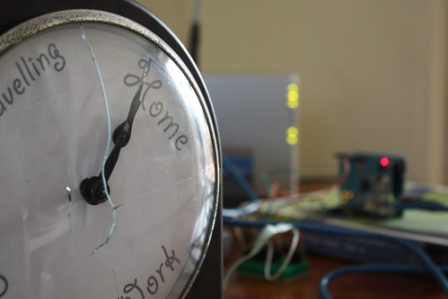
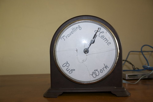
(Unfortunately hardware hacking can have its casualties, as you can see the glass on the face of the clock was one)
I’ll be taking the clock along with me on the next Tech Bus Tour from London to Liverpool. I’ll be updating the face to show our progress between the locations as this should be more interesting than showing that I’m “Travelling” constantly. I’ll also open source the Arduino source code when I get around to tidying it up.
UPDATE 2011/11/16: It’s now possible to buy a mapme.at WhereDial “Weasley Clock” just like this one!
UPDATE 2009/01/04: The code is now available on github, I haven’t had time to fully clean it up and add comments throughout but hopefully it’ll be useful anyway. Download the code here.
-
New mapping APIs available from CloudMade
If you’ve been following my Twitters you’ll be well aware that I’ve just spent the past week in San Francisco. I came here to attend, and speak at, the launch event for CloudMade’s new APIs for location based services. CloudMade is a company that was launched around 18 months ago by Steve Coast, the founder of the OpenStreetMap project, and Nick Black, a core member of the OSM project. The aim of their company is to bring the power of crowd sourced data, specifically OSM data, to more developers and to commercial companies around the world. The first step of this was of course to develop some products to make this possible and to make them available to the world, hence this event.
The event was split into four main sections. Steve started by giving an overview of the OSM project, its history and some glimpses of what’s likely to happen in the future. Nick then came on stage to explain their ideas behind forming CloudMade and what they’re doing to get OSM data into the hands of more people. After this I and four other developers who have been working with CloudMade’s APIs got on stage to give 5 minute presentations about our experiences developing with the new APIs.
Andrew Turner, CTO of GeoCommons, explained how they have integrated CloudMade’s tiles into their Maker application and talked about how the new Style Editor enables great looking mashups. Jaak Laineste of Nutiteq told us how they’ve been integrating CloudMade’s tile, geocoding and routing services into their Mobile map libraries. I talked about my experiences working with the new APIs, though I won’t go into too much detail here as I wouldn’t want to spoil the surprise for Thursday. Andre, of Advanced Flash Components, then showed us a live demo of CloudMade’s APIs being used in a flash application and showed the speedy responses that the API gave.
Cragg Nilson then talked more about the specific products that CloudMade are making available and how people can get access to them. Finally a Q&A; session allowed some light interrogation of the CloudMade team before we moved into another room for demo sessions. Jaak, Andre and I all had a plasma screen each that we used to demo what we’d discussed in our talks. The CloudMade team also demoed various other applications that were using their services, centred around a large range of mobile devices that are able to access the APIs using various applications.
I’ve been really impressed by what CloudMade are offering considering they are still a young company. While a large reason for the quality of their offerings is down to the great team they’ve built up, they do also have an advantage in that the data they’re using, and the license it’s built upon, allow them to offer so much more to the developers using their products. The OSM dataset is incredibly rich and can cover a wide range of features that often don’t get much coverage from standard data providers. Also because the data is free CloudMade can make all of it available in their APIs without having to worry about extra charges such as you might get if you wanted to return vectors from existing data providers.
Now the good news, if you’re reading this thinking “I wish I could’ve gone to San Francisco and seen these great talks”, you need not fret. The whole event is being repeated in London on Thursday 12th. It’s currently oversubscribed but if you are interested in going I believe they’ve managed to arrange extra room so there shouldn’t be a problem with more people going. This page should give more details about the CloudMade launch event in London.
Oh yes, and as a hint to what I’ll be talking about on Thursday, take a look at the new logo for one of my existing mapping sites:


subscribe via RSS or via JSON Feed