Multimap and OSM Maps on iPhone
I really did think that once I’d left Multimap I’d be doing lots of blog posts about all the technologies that I’d been playing around with. Somehow even though I’m not working I’ve still been really busy, I didn’t get time to write any code until last Wednesday!
Anyway, last week I finally gave in and bought myself an iPhone, of course one of the first things I did when I got it was to try my simple, functional map page on it. This map page is just a basic Multimap Open API implementation that I’ve set up with just enough features to do what I generally need. It shows OSM maps, it allows geocoding (hover over the white bar at the top to have it drop down), it has mouse-wheel zooming and it lets me click through to edit the OSM maps at the point I’m viewing, that’s generally about all I need. Oh yes, it’ll also remember your last viewed location in the hash of the URL and in a cookie, I have it set-up as a bookmark at the top of my browser simply labelled Map (feel free to drag that up there yourself).
If you look at the page in a regular browser you’ll see that it’s pretty basic, though it does have a 5 elements “obscuring” the map (ignoring the logos) the full-screen nature of the map makes this less of an issue. However if you take a look on an iPhone, the story is a little different:
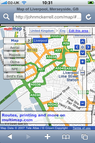
As you can see, things are a little cluttered so I needed to strip things down. The link through to multimap is a bit useless as you can’t print from an iPhone and using multimap’s site to lookup a route would likely crash Safari so that went straight away. The OSM editor is written in flash which the iPhone also can’t handle so the “Edit this area” link went too. After that it’s just the widgets. The location widget is useful but not absolutely required so I pulled that one out. The buttons on the pan/zoom widget are too small to click on the iPhone so I got rid of that too. The map type widget was quite functional but just too big so I decided to keep that in but try to find a way to get it out of the way.
My first attempt at keeping it involved restyling the widget. All of the widgets in the Multimap API can be completely restyled. The API supports you in doing this by allowing you to pass a “class name” when constructing the widget. When you do this the default Multimap class name, e.g. “MMPanZoomWidget”, is replaced by your own, e.g. “altpanzoom”. The resultant widget has no styles whatsoever and can be restyled in whatever way you want, more info about restyling widgets here. I decided to try shrinking the text a bit and then just giving the widget a basic white background and black border.
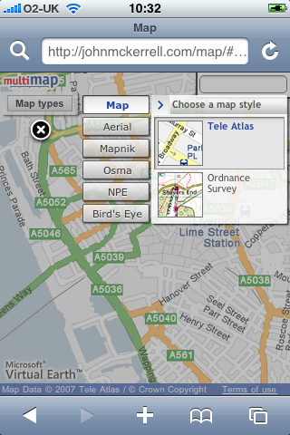
The problem with restyling the map type widget though is that it has a lot of extra behaviour built in; it can display relationships (click on “Mapnik” and then click on the arrow that shows up, you then get a menu of “Normal”, “Highlighted”, “Mobile”), it can display alternative map types (when an arrow pops up next to “Map”, click it to be offered alternatives such as “Ordnance Survey”) and there’s also a lot of interaction involved in the “Bird’s eye” maps. What this means is that if you want to do anything more complex than changing fonts or colours, restyling the widget is a lot of work. And after all, the widget looks quite nice and it’s shiny nature might fit in quite well on the iPhone so I really wanted to keep it. That’s when I came up with the idea that I’ve decided to stick with. When the map comes up there is a single relatively innocuous button marked “Map Types”. Clicking on this dims the map and pops up the Map Type widget in its full glory, you can then enter the menus or select a map type as you desire at which point the widget disappears and the map shows up again. You can also click the “X” if you decide you don’t want to change map type after all.
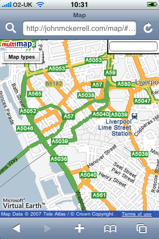
Final visual problem is the search box. The iPhone doesn’t really do mouse hover type events too well so I couldn’t really have it popping down, also it was a little big to start off with. I ended up shrinking it down and popping it permanently into the top right corner. Removed the descriptive text and the submit button as they’re not all that necessary.
Of course once you’ve removed the pan/zoom widget it does become a little more difficult to interact with the map. By default Safari on the iPhone does not create the necessary mouse related events to allow any of the default map interactions to work. These would be dragging the map, double clicking to zoom in and double right clicking to zoom out. With version 2.0 of the iPhone software, Apple have allowed some access through JavaScript to the gesture interface. Although their documentation wasn’t great I did find some useful documentation elsewhere. I’ve now managed to setup the page so that the pinching gesture allows you to zoom in and out, and clicking somewhere on the map will move the map to that point. While it would obviously be nice to be able to drag the draggable map, it seems the iPhone is not really capable of doing this with the Multimap API. In fact I’ve also tried a similar thing with the Google Maps API and it just seems the iPhone is not fast enough to provide live draggable maps with the APIs as they’re currently built.
So to conclude, this now works relatively well, it should be able to show me OSM maps when I’m out mapping and show me Ordnance Survey maps while I’m walking in the hills. Unfortunately it doesn’t look like dragging the map will be possible any time soon. It would also be nice to be able to have the map scaling more interactively, so that you can be sure you’ve pinched enough to show what you want to see. The Multimap API doesn’t currently expose its map scaling functionality in a way that outside developers can make use of it, even if this was changed though I doubt the iPhone would be fast enough to make use of it. Really this just started out with me attempting to tidy up the map a little so that it could work with the iPhone and I’m pretty happy with how it turned out. If you want to try it out just go to http://johnmckerrell.com/map/ on your iPhone, it’s the same URL for normal web browsers and for iPhones, it’ll detect which you’re using and display it appropriately.
Check back here shortly to read about my attempts to display maps on Nintendo devices, for now though here’s a final screenshot to show how well the map and widget work in horizontal mode:
Technorati tags: api, apple, iphone, osm, map, openstreetmap, phone, multimap
Comments
— Tyom